| Citation: | ZHANG Y,LU Q,ZHANG Y W,et al. Spaceborne GNSS-R sea surface height inversion model using FY-3E[J]. Journal of Beijing University of Aeronautics and Astronautics,2025,51(10):3262-3272 (in Chinese) doi: 10.13700/j.bh.1001-5965.2023.0540

|
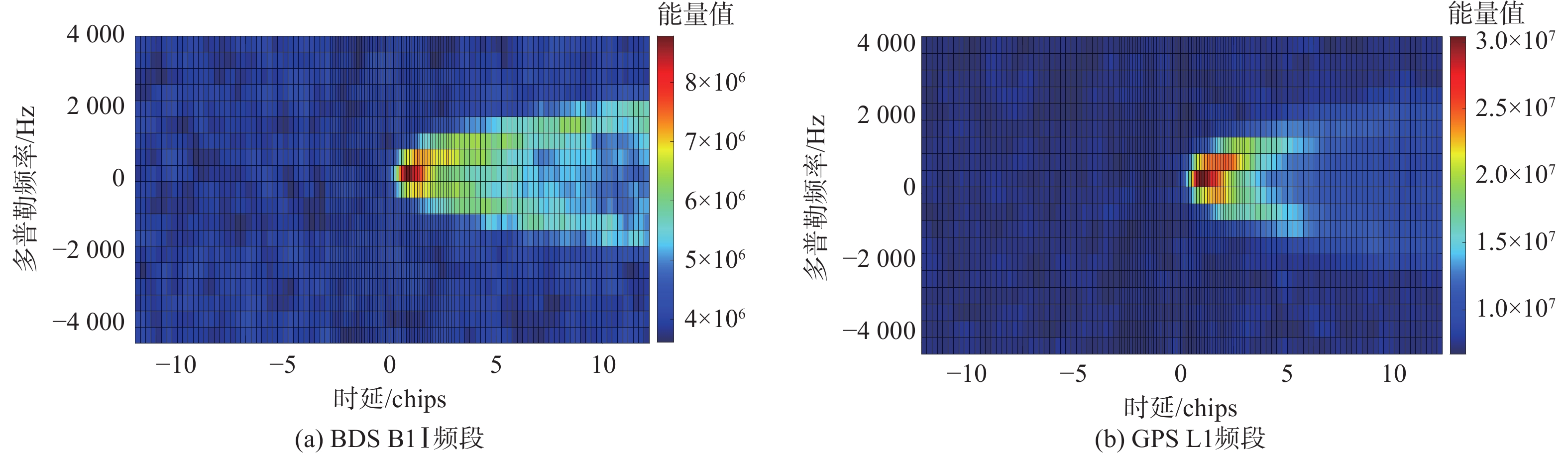
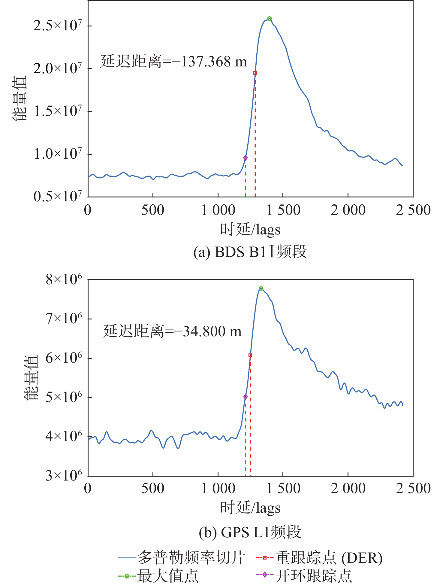
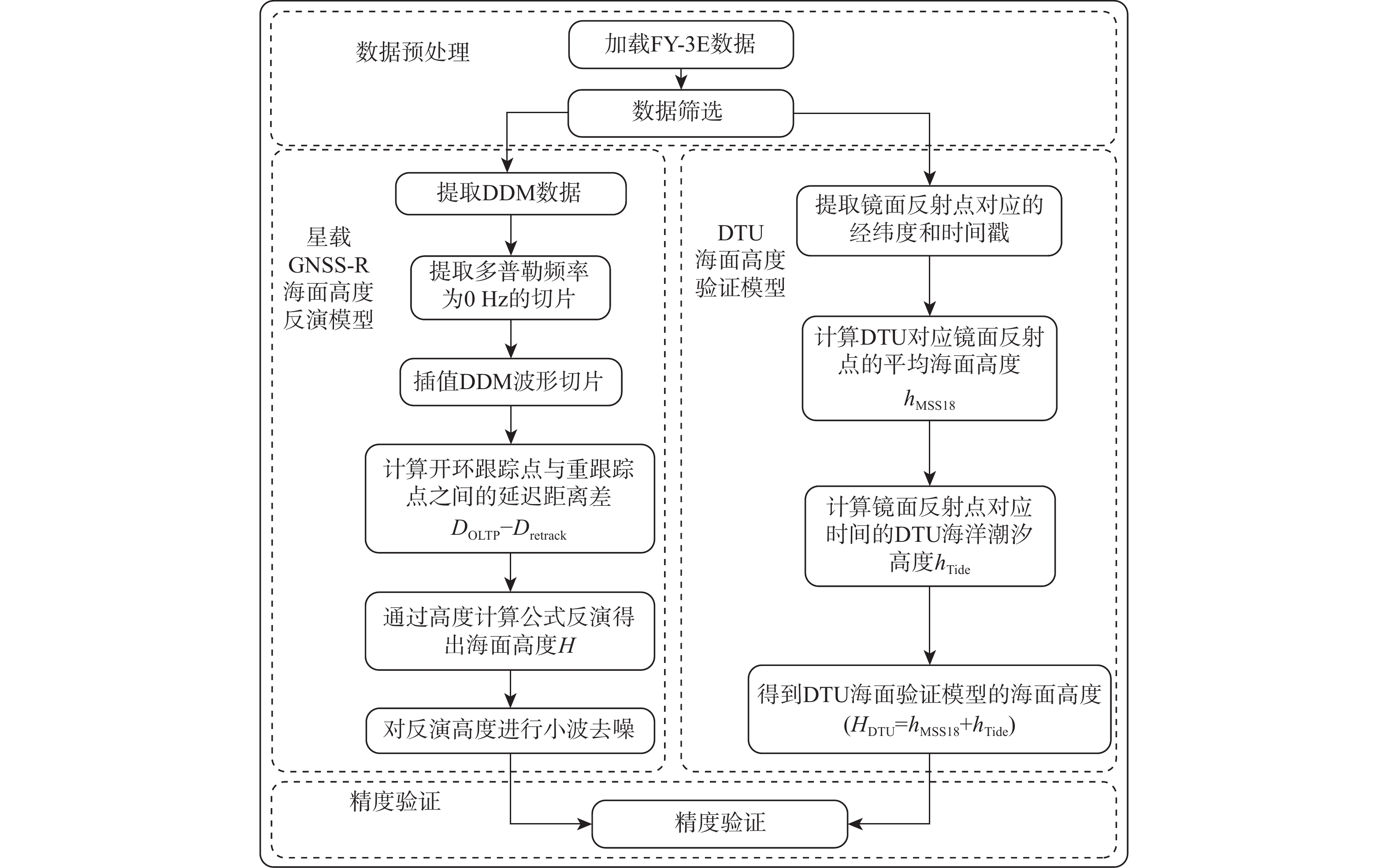
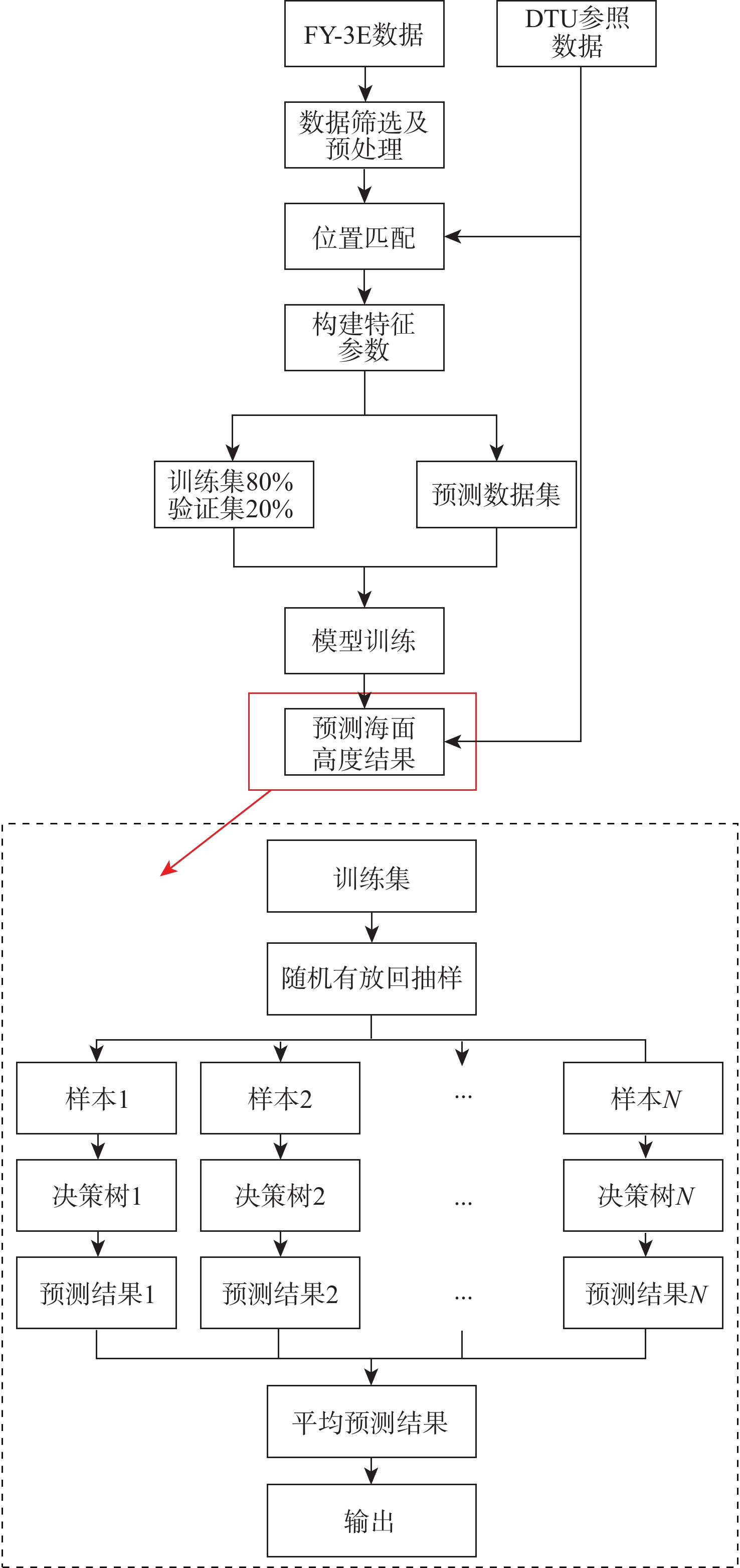
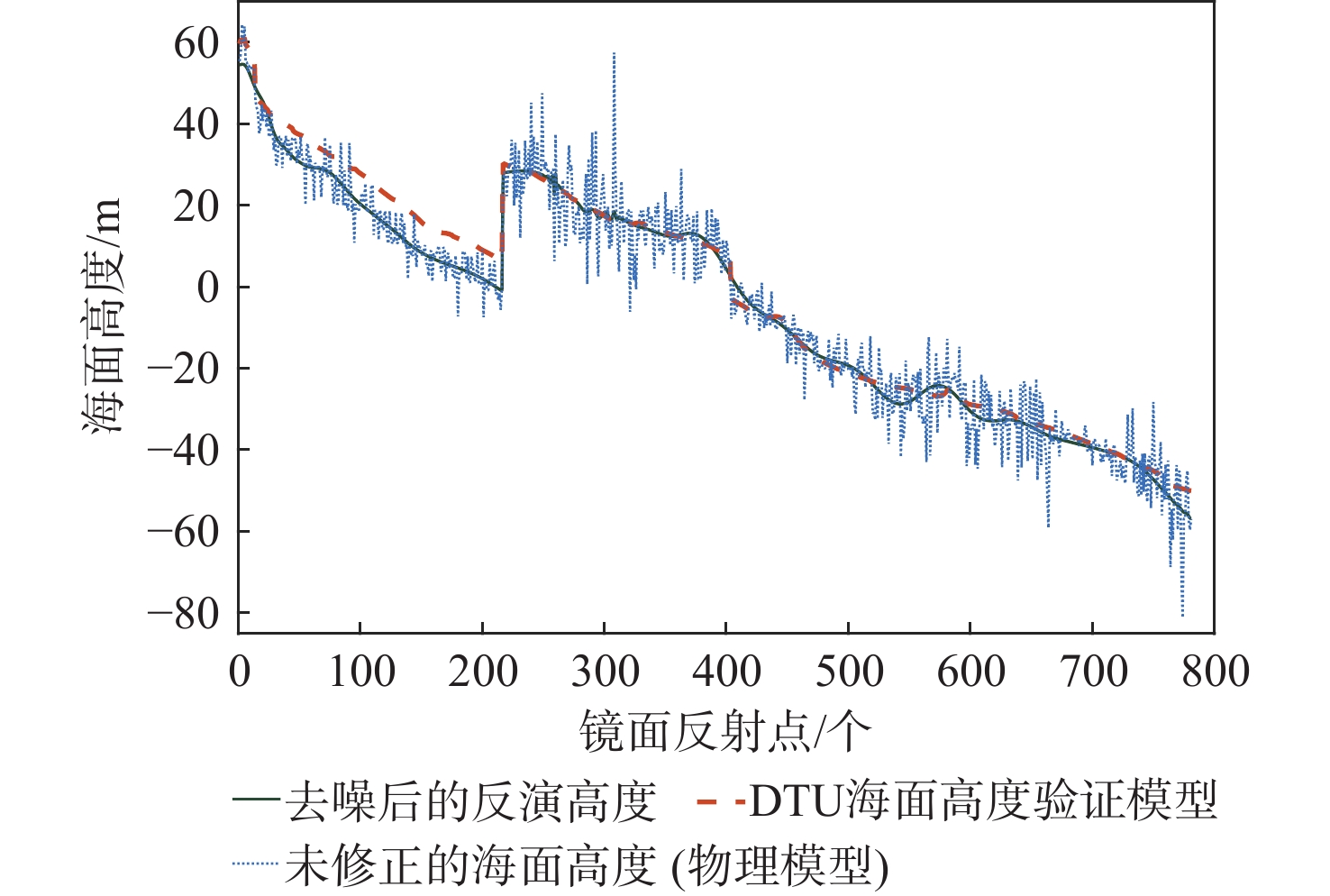
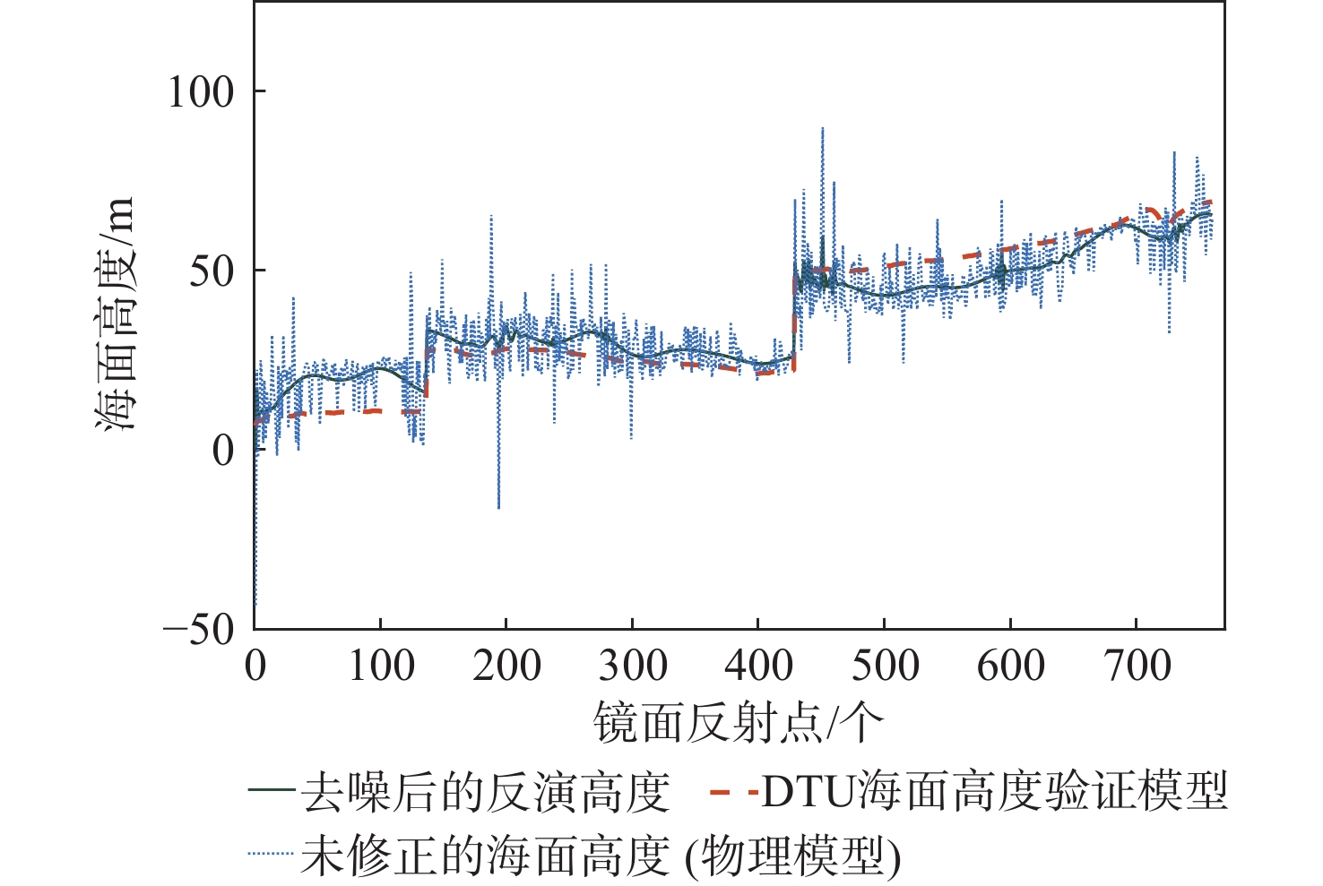
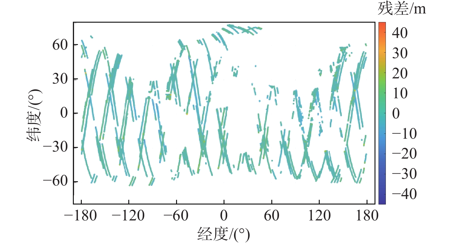
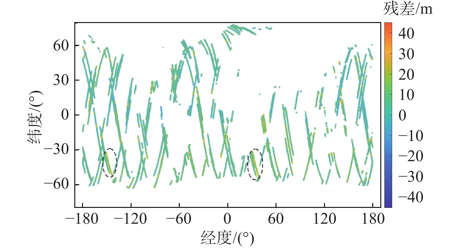
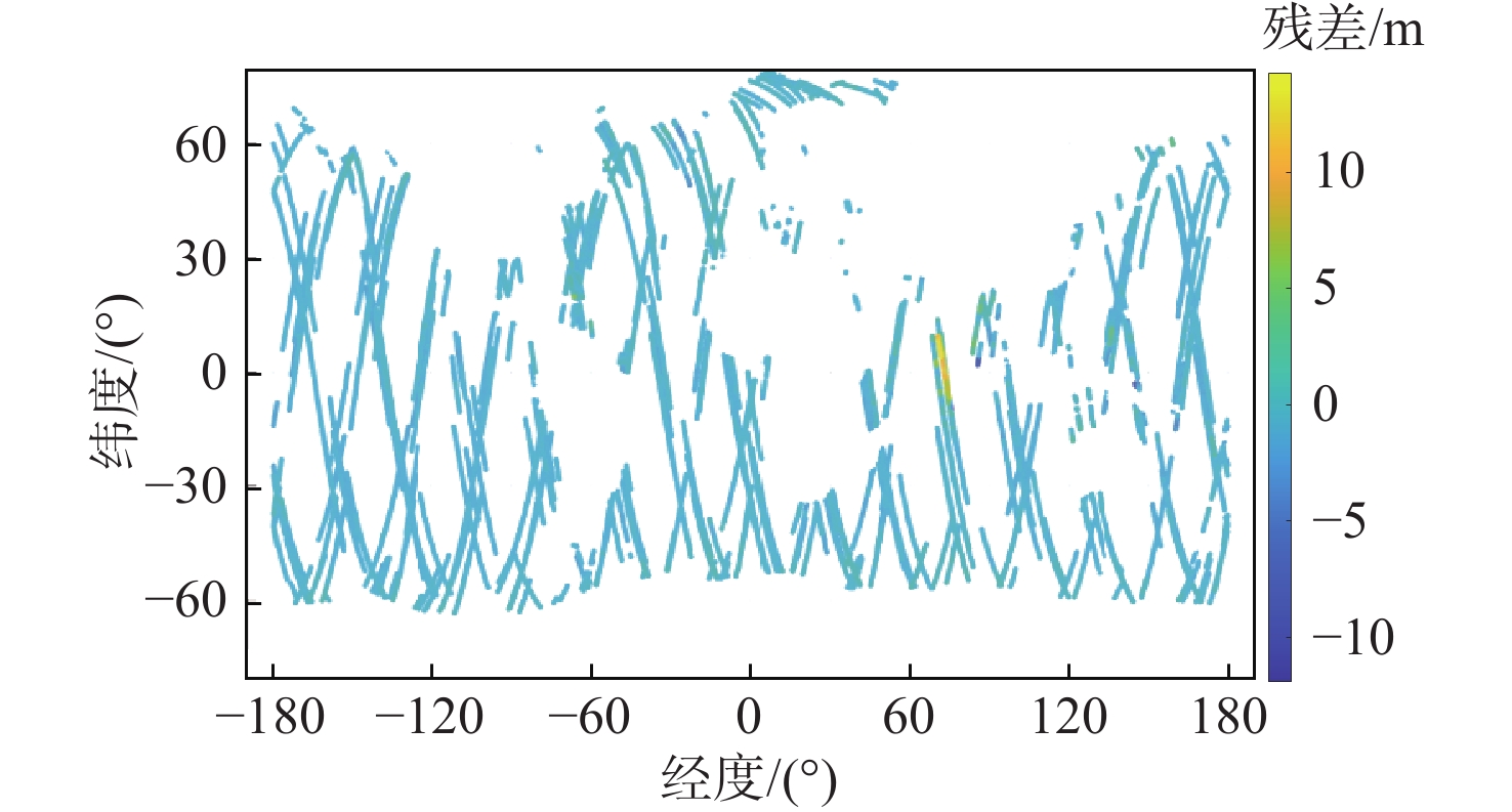
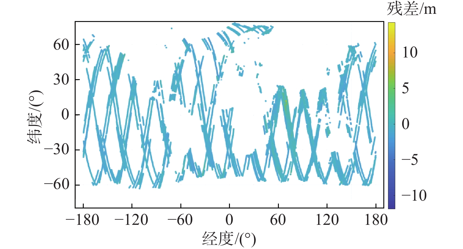
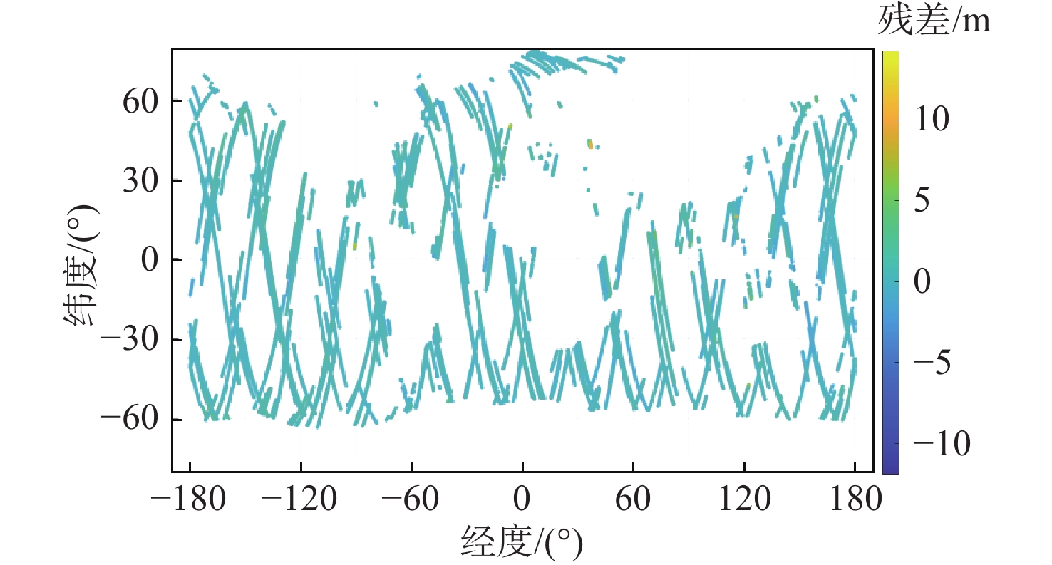
Sea surface height (SSH) is of great significance in fields such as oceanography and meteorology. Given the current absence of research utilizing the unevenly distributed delay-Doppler map (DDM) data from China’s independently developed FengYun-3E (FY-3E) global navigation satellite system occultation sounderⅡ (GNOS-Ⅱ), this paper employs DDM-based SSH retrieval technology and validates the retrieval accuracy using the Danish DTU18 global mean SSH model and tidal model. The SSH retrieval performance of reflected signals from the global positioning system (GPS) and the spaceborne Beidou navigation satellite system (BDS) is evaluated individually in this research using both conventional physical models and machine learning techniques. The results demonstrate that due to the higher chip resolution of BDS B1Ⅰ signals compared to GPS, the maximum mean absolute error (MAE) of the global SSH inversion using the physical model of BDS is about 3.0 m, which is significantly better than that of the GPS (maximum MAE is about 5.0 m). Both GPS and BDS may produce good inversion results using the random forest (RF) and convolutional neural network (CNN) models; their best MAE is approximately 0.4 m. Compared with the inversion results of the UK TDS-1 data, the GPS inversion accuracy is improved by about 15% in the physical model, which verifies the validity of the global navigation satellite system-reflectometry (GNSS-R) remote sensing data of the FY-3E GNOS-Ⅱ. The research findings in this paper are of great significance for promoting the application of domestic FY-3E GNSS-R SSH measurements.

| [1] |
陈锐志, 王磊, 李德仁, 等. 导航与遥感技术融合综述[J]. 测绘学报, 2019, 48(12): 1507-1522.
CHEN R Z, WANG L, LI D R, et al. A survey on the fusion of the navigation and the remote sensing techniques[J]. Acta Geodaetica et Cartographica Sinica, 2019, 48(12): 1507-1522(in Chinese).
|
| [2] |
MARTIN-NEIRA M. A passive reflectometry and interferometry system (PARIS): application to ocean altimetry[J]. ESA Journal, 1993, 17(4): 331-335.
|
| [3] |
张云, 张杨阳, 孟婉婷, 等. 机载GNSS反射信号海面测高模型的研究[J]. 海洋学报, 2020, 42(3): 149-156. doi: 10.3969/j.issn.0253-4193.2020.03.014
ZHANG Y, ZHANG Y Y, MENG W T, et al. Research on sea surface altimetry model of airborne GNSS reflected signal[J]. Haiyang Xuebao, 2020, 42(3): 149-156(in Chinese). doi: 10.3969/j.issn.0253-4193.2020.03.014
|
| [4] |
ZHANG Y, TIAN L M, MENG W T, et al. Feasibility of code-level altimetry using coastal BeiDou reflection (BeiDou-R) setups[J]. IEEE Journal of Selected Topics in Applied Earth Observations and Remote Sensing, 2015, 8(8): 4130-4140. doi: 10.1109/JSTARS.2015.2446684
|
| [5] |
ZHANG Y, LI B B, TIAN L M, et al. Phase altimetry using reflected signals from BeiDou GEO satellites[J]. IEEE Geoscience and Remote Sensing Letters, 2016, 13(10): 1410-1414. doi: 10.1109/LGRS.2016.2578361
|
| [6] |
李黄, 夏青, 尹聪, 等. 我国GNSS-R遥感技术的研究现状与未来发展趋势[J]. 雷达学报, 2013, 2(4): 389-399. doi: 10.3724/SP.J.1300.2013.13080
LI H, XIA Q, YIN C, et al. The current status of research on GNSS-R remote sensing technology in China and future development[J]. Journal of Radars, 2013, 2(4): 389-399(in Chinese). doi: 10.3724/SP.J.1300.2013.13080
|
| [7] |
刘风玲, 张云, 孟婉婷, 等. UK-DMC卫星接收机GNSS反射信号的应用分析[J]. 遥感信息, 2015, 30(1): 90-95. doi: 10.3969/j.issn.1000-3177.2015.01.015
LIU F L, ZHANG Y, MENG W T, et al. Application analysis of airborne GNSS reflected data from UK-DMC satellite receiver[J]. Remote Sensing Information, 2015, 30(1): 90-95(in Chinese). doi: 10.3969/j.issn.1000-3177.2015.01.015
|
| [8] |
CLARIZIA M P, RUF C, CIPOLLINI P, et al. First spaceborne observation of sea surface height using GPS-reflectometry[J]. Geophysical Research Letters, 2016, 43(2): 767-774. doi: 10.1002/2015GL066624
|
| [9] |
MASHBURN J, AXELRAD P, LOWE S T, et al. Global ocean altimetry with GNSS reflections from TechDemoSat-1[J]. IEEE Transactions on Geoscience and Remote Sensing, 2018, 56(7): 4088-4097. doi: 10.1109/TGRS.2018.2823316
|
| [10] |
张云, 马德皓, 孟婉婷, 等. 基于TechDemoSat-1卫星的GPS反射信号海面高度反演[J]. 北京麻豆精品秘 国产传媒学报, 2021, 47(10): 1941-1948.
ZHANG Y, MA D H, MENG W T, et al. Sea surface height inversion of GPS reflected signal based on TechDemoSat-1 satellite[J]. Journal of Beijing University of Aeronautics and Astronautics, 2021, 47(10): 1941-1948(in Chinese).
|
| [11] |
WANG Q, ZHENG W, WU F, et al. A new GNSS-R altimetry algorithm based on machine learning fusion model and feature optimization to improve the precision of sea surface height retrieval[J]. Frontiers in Earth Science, 2021, 9: 730565. doi: 10.3389/feart.2021.730565
|
| [12] |
ZHANG Y, HUANG S, HAN Y L, et al. Machine learning methods for spaceborne GNSS-R sea surface height measurement from TDS-1[J]. IEEE Journal of Selected Topics in Applied Earth Observations and Remote Sensing, 2022, 15: 1079-1088.
|
| [13] |
ZHANG Y, LU Q, JIN Q, et al. Global sea surface height measurement from CYGNSS based on machine learning[J]. IEEE Journal of Selected Topics in Applied Earth Observations and Remote Sensing, 2022, 16: 841-852.
|
| [14] |
ZHANG P, HU X Q, LU Q F, et al. FY-3E: the first operational meteorological satellite mission in an early morning orbit[J]. Advances in Atmospheric Sciences, 2022, 39(1): 1-8. doi: 10.1007/s00376-021-1304-7
|
| [15] |
SUN Y Q, WANG X Y, DU Q F, et al. The status and progress of Fengyun-3E GNOS Ⅱ mission for GNSS remote sensing[C]//Proceedings of the IEEE International Geoscience and Remote Sensing Symposium. Piscataway: IEEE Press, 2019: 5181-5184.
|
| [16] |
YANG G L, BAI W H, WANG J S, et al. FY3E GNOS Ⅱ GNSS reflectometry: mission review and first results[J]. Remote Sensing, 2022, 14(4): 988. doi: 10.3390/rs14040988
|
| [17] |
ANDERSEN O B, KNUDSEN P. The DTU2010MSS mean sea surface in the arctic-for and with Cyrosat-2 data[J]. Cryosat Validation Workshop, 2011, 693: 28.
|
| [18] |
PICCIONI G, ANDERSEN O B, STENSENG L. SAR altimetry for mean sea surface determination in the arctic DTU15MSS[C]//Proceedings of the Sentinel-3 for Science Workshop. Venice : European Space Agency, 2015: 75.
|
| [19] |
GARRISON J L, KATZBERG S J. The application of reflected GPS signals to ocean remote sensing[J]. Remote Sensing of Environment, 2000, 73(2): 175-187. doi: 10.1016/S0034-4257(00)00092-4
|

Figures(16) / Tables(5)
Copyright © Journal of Beijing University of Aeronautics and Astronautics
Address: Editorial Department of Journal of Beijing University of Aeronautics and Astronautics, 37 Xueyuan Road, Haidian District, Beijing Post Code: 100191 Email: jbuaa@cq5520.com
Supported by:
Beijing Renhe Information Technology Co., Ltd.


 DownLoad: